
About the tools
We use river assessment tools to visualise data and determine the environmental value, condition and type of rivers. We also use the tools to measure and evaluate how water-dependent environments respond to different patterns of surface water flow. These tools help us to understand and track changes to the river's physical form, its fringing vegetation, and the wildlife that depend on river ecosystems.
River assessment tools help us to evaluate water management strategies that aim to protect and maintain the environment. We use this information to inform water sharing plans and other legislation under the Water Management Act 2000 (NSW).
Tools we use to monitor changes
The NSW River Condition Index (RCI) is a long-term reporting tool for assessing river condition. The tool uses inputs from a range of indicators to cover all aspects of river health. The indicators include water quality, river form, surrounding vegetation and the animals that live in rivers.
The NSW RCI was developed and first published in 2012, using the Framework for the Assessment of River and Wetland Health (FARWH). The FARWH approach recognises the effects of catchment disturbance, physical form of the landscape, long term flow patterns, water quality, riparian vegetation extent and condition, and aquatic life as measures of river health. The FARWH method uses existing data collection activities and converts them into a standardised score of river health that is nationally comparable.

The NSW RCI (2023) is available via the SEED open data portal and as an interactive map.
Inputs into the NSW River Condition Index
The RCI includes riparian vegetation condition, geomorphic condition, hydrologic stress, biodiversity condition, catchment disturbance and water quality. Each is explained below.
Riparian vegetation condition
A riparian zone or riparian area is the interface between land and a river or stream. Riparian vegetation are the plants occupying this zone. Riparian vegetation is more diverse and abundant than nearby terrestrial habitats. Healthy riparian zones provide many benefits, including:
- habitat for native birds, reptiles, frogs, mammals and insects
- shade to help moderate water temperature
- organic input to waterways
- bank stability
- a filter for runoff that trap land-based sediment and nutrients.
The River Condition Index assesses riparian vegetation condition using:
- riparian zone width
- the extent of native woody vegetation
- the extent of native non-woody vegetation
- landscape connectivity (fragmentation and patch size).

Figure 1. Good versus poor riparian vegetation condition.
Geomorphic condition
Rivers are diverse in their physical character and behaviour. Human-induced changes in a catchment affect river processes.
Geomorphic condition measures natural channel function against its response to change. Rivers in good geomorphic condition are important for instream biodiversity, ecological diversity, and overall catchment condition. There is a strong connection between healthy floodplain, channel and groundwater. Rivers in poor geomorphic condition are indicative of stressed catchments. These rivers are unlikely to favour aquatic biodiversity. This is due to a reduction in geomorphic stability and available habitat. The connection between floodplain and groundwater is lost as the channel incises into its bed.
The River Condition Index uses the River Styles Framework (see River Styles in NSW below) to assess geomorphic condition. The River Styles approach scores river reaches according to their river type, behaviour, condition, fragility and recovery potential, relative to a reference condition.
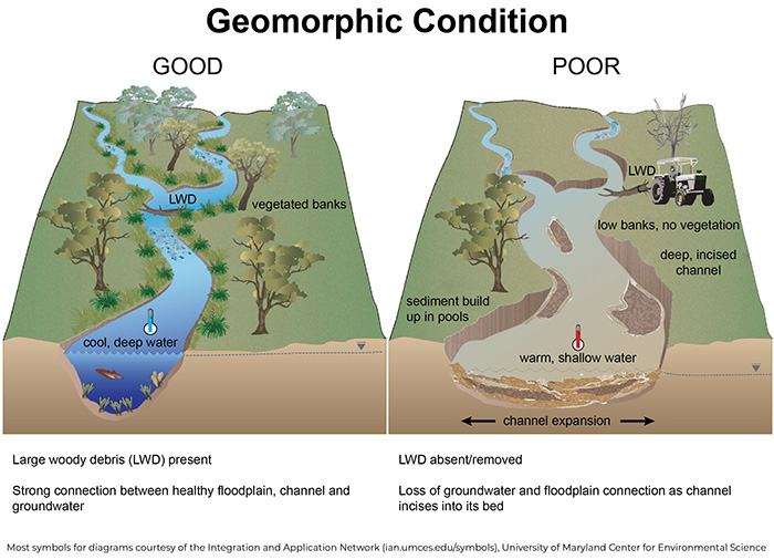
Figure 2. Good versus poor geomorphic condition
Hydrologic stress
Hydrologic stress is a measure of change to natural flow regimes in catchments. It is the amount of water extracted relative to river flow. Hydrologic stress shows the risks posed to instream values from extraction. It is an indicator of the degree of competition between extractors. Hydrologic stress helps to assess river condition.

Figure 3. Hydrologic stress in low flow conditions and water extraction in low flow conditions.

Figure 4. Hydrologic stress in no flow conditions and water extraction in no flow conditions.
River biodiversity condition
Aquatic biodiversity is the variety of plants and animals that live in aquatic habitats such as rivers and streams. Aquatic species include fish, macroinvertebrates, frogs, reptiles, aquatic and riparian vegetation. Aquatic species rely on healthy rivers and diverse habitats for survival and reproduction. These biotic indicators can help assess river condition. Reduced river condition is associated with loss of species.

Figure 5. Good versus poor river biodiversity condition.
Catchment disturbance
Many activities in a catchment affect river health and resilience. These include land-use, habitat modification, infrastructure, and land management practices.
The Catchment Disturbance Index is a catchment summary of the type and extent of change in a catchment. It helps to assess river condition and includes the following features:
- infrastructure
- land-use
- land cover change.
Infrastructure measures the extent of roads, unsealed roads, railways, utilities (e.g. power, pipes) and walking tracks. Land-use measures the extent of horticulture, orchards, cropping, cotton, rice, transport, production forests, grazing and wilderness/National park areas. Land cover change measures the loss of woody vegetation using satellite imagery.

Figure 6. Good versus poor catchment disturbance.
Water quality
Water quality is a key driver of aquatic ecosystem condition. Both natural characteristics and human activities can influence water quality and thus ecosystem condition. For example, local geology can influence salt and nutrient inputs while climate, riparian vegetation extent and health, and stream flow influence sediment and nutrient loads. There are a wide range of human activities that can impact water quality. These include water extraction, pollution and changed land use.

Figure 7: Good versus poor water quality.
The River Condition Index Impact Assessment Tool helps predict the impact of aquifer interference activities on river health and is a by-product of the NSW River Condition Index. It was developed for use by proponents and regulatory authorities in the NSW planning, approvals and monitoring process for aquifer interference activities.
Under the Aquifer Interference Policy, developers must consider thresholds for key minimal impacts. These include groundwater sources in relation to water table and groundwater pressure drawdown, as well as groundwater and surface water quality. Proponents must show that their actions will not reduce the condition of nearby waterways, using the NSW River Condition Index as a baseline.
The River Condition Index Impact Assessment Tool is a predictive impact assessment tool to assess whether coal seam gas, open cut mining, long wall mining and sand and gravel extraction projects will have a significant impact on river health. It uses four of the NSW River Condition Index sub-indices and a series of rules to compare ‘current’ versus ‘predicted future’ condition.
A Proof of Concept report documents the testing and development of the River Condition Index Impact Assessment Tool, detailing the research behind each sub-index and the establishment of their associated rules.
Rivers are diverse in their physical character and behaviour. Different types of rivers have different processes and sensitivity to change. To manage rivers effectively, we need to understand the existing geomorphic condition of the river, its inherent fragility (sensitivity to change) and likelihood of recovery. This all requires a consistent method to characterise the types of rivers we are working with and how they function.
River Styles Framework
The River Styles Framework is a system for understanding and managing rivers in all their diverse geomorphic characteristics and behaviours. Developed at Macquarie University, the framework is a method for classifying river character, behaviour, condition and recovery potential. It has been used extensively in Australia and overseas to categorise river types and describe river behaviour. The NSW River Styles Database uses the River Styles Framework.

NSW River Styles Database
The department and Macquarie University have together developed the State-wide NSW River Styles Database. The database is the largest and most comprehensive dataset of geomorphic river character and condition available in Australia. It serves as a decision support tool for integrated river management.
The NSW River Styles Database captures information for more than 220,000 km of river reaches across NSW. The database provides a consistent and data-rich platform for the development of river management tools, systems and strategies at state-wide, regional and local/catchment levels. You can view NSW River Styles information using our mapping tool.
Users can access information about the type, geomorphic stream condition, recovery potential and geomorphic priority for river management of rivers in NSW. This data can be integrated into decision support systems to help prioritise and plan river management programs.
Visit the NSW River Styles mapping tool
NSW River Styles spatial dataset companion document
The High Ecological Values Aquatic Ecosystems (HEVAE) framework identifies surface and groundwater systems with high conservation values and presents them as a spatial mapping tool.
Ecological value is how we perceive the importance of an ecosystem. We use the High Ecological Value Aquatic Ecosystems (HEVAE) national framework to assess the ecological value of rivers. This tool assigns an instream value to a length of river to determine the importance of each river relative to others. Identifying rivers of high importance or high value allows for their protection and enhancement. This is essential for water sharing rules in NSW rivers.
We rely on information and data from across government agencies for the HEVAE tool. Over time the tool has improved due to technology and new contemporary data. Our assessment has gone from a water source scale approach to a single reach approach. You can find the instream value of inland freshwater rivers and coastal rivers above the tidal limit using our HEVAE mapping tool.
Figure 1 shows the four HEVAE criteria used in our assessment of NSW river values. At present, in our assessment of coastal rivers, we are unable to include the vital habitat criteria as the data is not available. As more information becomes available for coastal rivers, we will include it. We also will include the fifth criteria, representativeness, for inland and coastal rivers as more information becomes available.

Overall HEVAE (instream value)
We use the HEVAE in our water sharing plan risk assessment work to describe the instream values that may be at risk from surface water extraction. We also use the HEVAE in combination with other tools to assess change in river condition. The Applying the High Ecological Value Aquatic Ecosystem (HEVAE) Framework across NSW rivers report (PDF, 3740.89 KB) outlines how the HEVAE framework has been applied in NSW.
About risk assessments
Risk assessments allow us to identify and prioritise where surface water environments are at greatest risk. That is, where we should focus our monitoring and research.
A risk assessment is a key step in preparing water resource plans and water sharing plans. It looks at risks to the condition and continued availability of water resources.
The risk assessment framework adopts a cause/threat/impact model. The model describes the risk pathway of impacts to a receptor. The risk level of an impact is a function of likelihood and consequence. The likelihood of a cause and threat occurring, and the consequence of the impact on the receptor. We use the following definitions for risk assessments:
- Likelihood: the probability that a cause will result in a threat. It is not a sign of the size of the threat, but rather conveys the probability that the threat will be significant.
- Consequence: the loss of value for an impacted receptor.
We assess the risk level using current strategies and rules as provided by the Water Management Act 2000 (NSW) and the relevant water sharing plan/s. The risk assessment outlines the management actions and mechanisms to address risks.

The figure combines the cause/threat/impact model and likelihood/consequence. As an example, it shows risks arising from river regulation and licensed surface water extraction.
The figure combines the cause/threat/impact model and likelihood/consequence. As an example, it shows risks arising from river regulation and licensed surface water extraction.